


SwitzerlandMobility
SwitzerlandMobility介绍
SwitzerlandMobility 应用程序是任何喜欢户外活动的人的完美伴侣,无论是夏季还是冬季。
发现新路线、获得灵感、规划和导航您的体验。
探索瑞士最具吸引力的路线
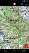
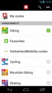
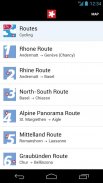
SwitzerlandMobility 应用程序提供瑞士和列支敦士登公国 1,500 条最有吸引力的路线的访问。夏季,您可以进行徒步旅行、骑自行车、山地自行车、滑冰和划独木舟等活动。冬季,您会发现各种各样的冬季远足小径、雪鞋路线、越野滑雪道和平底雪橇道。路线网络为您提供最高质量的地图,包括 swisstopo 的国家地图,比例尺高达 1:10,000。
简单的行程规划
您将找到每条路线的详尽描述和详细照片报告。这可以让您很好地了解现场会发生什么。公共交通站点(包括可直接链接到 SBB 应用程序的下次出发时间)以及有关住宿选择、景点、中途停留地点、自行车租赁和自行车服务站的大量附加信息,让您轻松准备行程。
安全出行
SwitzerlandMobility 路线是官方路线,并在当地设有路标。该应用程序还提供当前路线关闭和改道信息。该信息每天都会更新,因此您可以随时了解最新的详细信息。
位置跟踪和指南针功能
您始终可以使用 SwitzerlandMobility 应用程序找到正确的路线。您可以通过位置跟踪轻松查看您在地图上的位置。指南针功能可将地图与您正在寻找的方向对齐,以便您可以遵循计划的旅行。
规划您自己的旅行
在 swisstopo 地图上规划您自己的旅行。自动计算距离、上升和下降、高度剖面和所需时间。 SwissMobility Plus 可为您提供此功能(收费)。
在没有网络信号的情况下使用该应用程序
计划的旅行、地图部分和所有路线信息都可以在应用程序中离线使用。这对于没有网络接收的高山地形来说是理想的选择。使用您选择的内容保存任何地图部分。 SwissMobility Plus 可为您提供此功能(收费)。
在应用程序中记录您自己的旅行
通过 SwitzerlandMobility Plus,您可以将您的旅行自动记录在应用程序中。这为您提供了所有重要信息的概览,例如距离、海拔高度和所需时间。 SwissMobility Plus 也可提供此功能(收费)。
了解有关 SwitzerlandMobility Plus 的优势和附加功能的更多信息:www.switzerlandmobilty.ch/de/switzerlandmobility-plus
SwitzerlandMobility - 版本5.4.0
(14-04-2025)SwitzerlandMobility - APK信息
APK版本: 5.4.0程序包: ch.schweizmobilSwitzerlandMobility的最新版本
其他版本


同类应用


您可能还会喜欢……


